A mouse with a scroll wheel enables the user to use the scroll wheel to zoom in/out in an area of interest. Just move mouse cursor to the point that you would like to enlarge and scroll the wheel forward. Zooming is performed around the point, which is pointed by the mouse cursor. Scroll the wheel in the opposite direction to get a wider field of view. For those who are familiar with windows' "focus" concept it is useful to know that the map capture focus automatically when mouse rolls over. The cursor changes from an arrowhead to a cross indicating that map get focus. Once focused, the map is immediately ready to interact with user (pan or zoom); there is no need for an additional click on the map. When the mouse cursor leaves the map, the map control transfers focus to the map window.
Alternatively, zooming controls on the right side of map can be used.
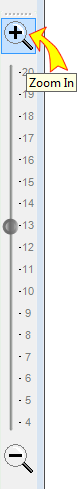
Zoom In Zooms in on the center of the map.
Zoom Out Zooms out around the center-point of the map.
The slider between the + / - buttons can be used to set the desired magnification.
Zoom In increases Rangecam and the Google map simultaneously. One wheel step changes the zoom 2 times. Zoom levels shown on the slider are consistent with Google standards. Google may not have hi-zoom maps for all areas. Rangecam warns the user about that and automatically switches to the Rangecam map only. As a rule in North America Satellite and Road maps have the largest zoom - up to level 19 in rural areas and up to level 20 in major cities.